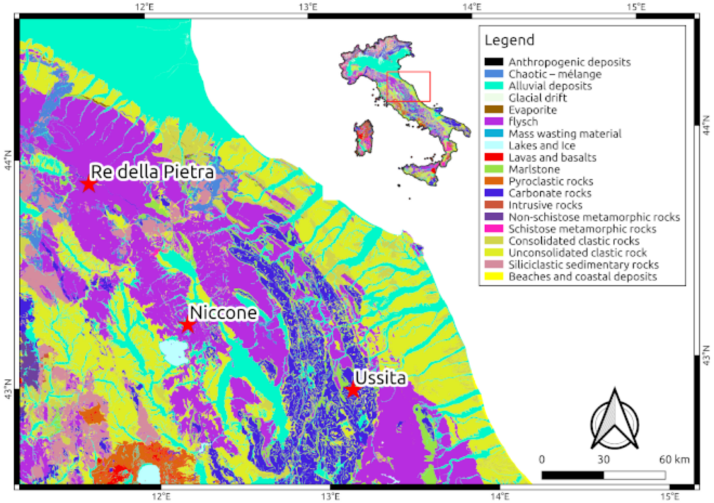
The Hydro4C project will be carried out within the Arno and Tiber basins (Central Italy). It will focus on catchments already monitored by the research units (RUs): Re della Pietra (sub-catchment of Arno river basin), and Niccone and Ussita, (sub-catchments of Tiber river basin). The following figure shows the location of the catchments superimposed on a lithological map of Italy.
RE DELLA PIETRA CATCHMENT
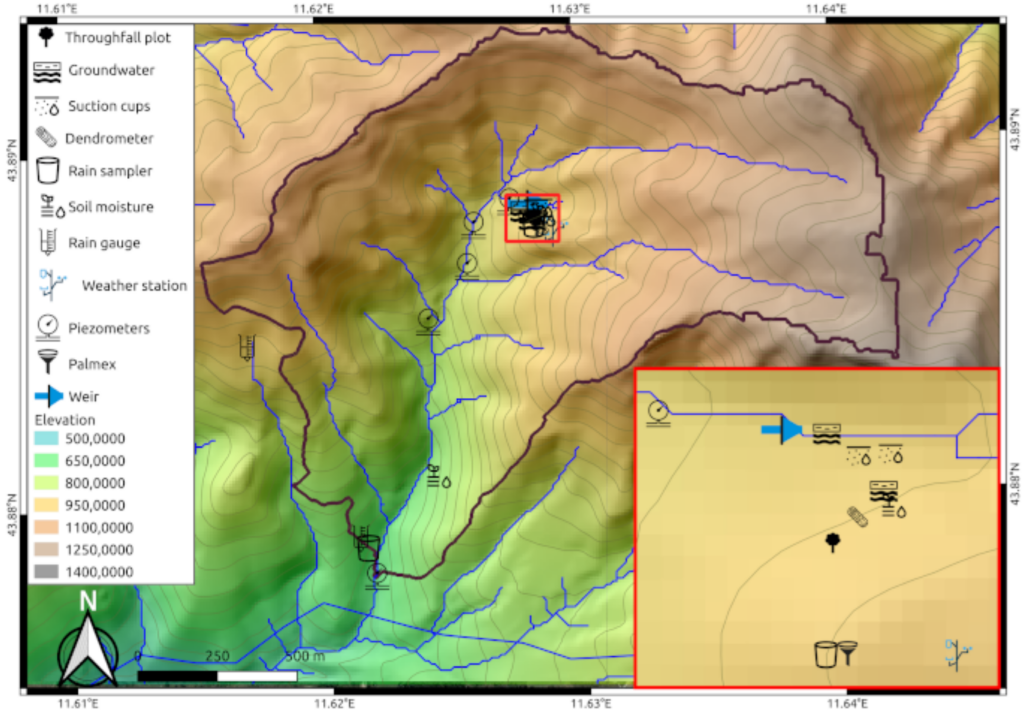
The Re della Pietra experimental catchment (~2 km²) is located in the Tuscan-Emilian Apennines, Mugello area, near Florence, Tuscany, Italy. The catchment elevation ranges from 640 m asl to 1281 m asl, while the aspect is predominantly North-West. The climate is typical of Mediterranean mountain environments, with an average annual temperature of 10,5°C and an annual precipitation of 1200 mm (2007-2016) spread along wet (winter, spring and fall) and dry (summer) periods. The area is densely vegetated with a few planted conifers and mostly deciduous tree species. The lithology consists of “Macigno”, a sandstone-turbidite unit with pelitic dominant lithofacies and a reduced thickness. Soils have sandy loam to sandy clay loam textures and are highly variable in depth (generally over 50cm). The catchment includes the measurement of the main weather parameter at one location and of rainfall only at two additional locations. The stream stage is monitored at four locations along the main stream and streamflow in a weir at the outlet of a 0.3 km² subcatchment. Here, soil moisture at two depths, sap flow, throughfall, and shallow groundwater level are measured along a steep hillslope. Samples for electrical conductivity (EC) and isotopic analysis (oxygen and hydrogen) are being collected from precipitation, stream water at different locations, soil water, spring water. The map of the catchment and the location of the monitoring and sampling sites are shown in the following figure.
NICCONE CATCHMENT
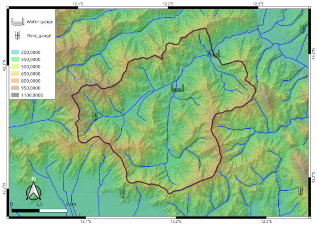
The Niccone catchment (see the following figure) covers an area of 137 km², with elevation ranging between 269 and 893 m above sea level and a mean catchment slope close to 25°. Woods (65%) and cropland/grassland (34.5.6%) are predominant in the area. Climate is Mediterranean and the average annual precipitation is close to 930 mm, with the maximum in November and minimum in July; the mean annual runoff is 230 mm. Lithology is characterized by flysch deposits, with layered sandstones interleaved with marls and pelitic levels. Landslides (mostly rotation or translational movements) occur over ~11% of the study area. The stream stage is monitored at the catchment outlet and another cross-section draining a ~56 km² sub-catchment. One rain gauge is located inside the catchment but the other five rain gauges are located close to the catchment, at distances ranging between 1 and 8 km. The Niccone catchment has been a pilot catchment for many hydrologic studies about spatial-temporal variability of soil moisture and runoff prediction when other sensors (some of which could be recovered and reactivated for Hydro4C) were active in the catchment. The time series of those sensors are available for the RUs.
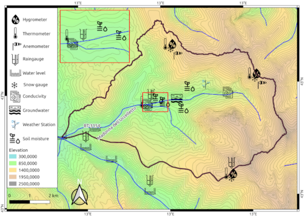
USSITA CATCHMENT
The Ussita River (see the following figure) is a right-bank tributary of the Nera River (Central Italy), having a catchment area of about 60 km² characterized by the outcropping of calcareous and marly-siliceous-calcareous rocks belonging to the Umbria-Marche Sequence. Groundwaters mainly provide river discharge, thanks to a set of permanent linear springs, the water of which comes from fractured basal carbonate aquifers. Deciduous tree species with some conifers cover the catchment area. The basal aquifer feeds mainly the Nera River with some flow directed towards the Ussita River (Madonna dell’Uccelletto springs). Starting from July 2017, daily water levels and rating curve of the Ussita River are available at RT-3154 section, which underlies a catchment area of approximately 45 km². River discharge data are reliable. Overall, the groundwater-surface water interactions of the Ussita River affect water quantity and quality even during floods. During recession periods or prolonged meteorological droughts, the river is fed only by groundwater. In these periods, the baseflow component can be carefully evaluated, allowing the quantification of CO2 flux coming from deep carbonate aquifers.