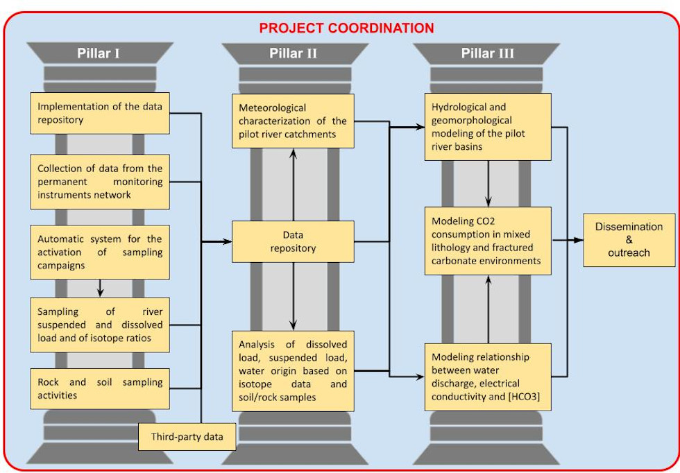
The project is organized into four WP. WP0 deals with project coordination, WP1 includes the first pillar activities, WP2 the second and third ones, while WP3 deals with dissemination (see the following figure). In the following, the different WPs are declined in terms of tasks, leading and timing.
WP0: COORDINATION (Lead: CNR, Co: All RUs)
T0.1 (Lead CNR) Project agenda and collaborating/integrating WPs
• RUs coordination and definition of internal communication channels
• Project agenda
T0.2 (Lead UniPG) Stakeholder mapping/engaging
• Engaging existing stakeholders
• Searching for other potential stakeholders
T0.3 (Lead CNR) Design and implementation of the data repository
• Designing data repository
• Implementing data repository
WP1: HYDROLOGICAL, HYDROGEOCHEMICAL AND SEDIMENT MONITORING (Lead: UniFI, Co: CNR, UniPG)
T1.1 (Lead UniFI) Design and installation of the monitoring instruments network
• Designing of the monitoring instruments network
• Installation and connection with the data repository
T1.2 (Lead CNR) Design and implementation of an automatic system for the activation of sampling campaigns during and immediately after intense meteorological events
• Designing of the automatic system
• Implementation of the automatic system
T1.3 (Lead CNR) Design and execution of the spatial and temporal sampling activities of streams suspended and dissolved load
• Defining rules for the sampling of streams’ water
• Scheduling and executing the streams’ water sampling campaign
T1.4 (Lead UniPG) Design and execution of rock/soil sampling activities
• Defining rules for the sampling of rock/soil
• Scheduling and executing the rock/soil sampling campaign
WP2: LABORATORY AND MODELING ACTIVITIES (Lead: UniPG, Co: CNR, UniFI)
T2.1 (Lead UniFI) Analysis of DSC (dissolved sediment concentration), SSC (suspended sediment concentration), isotope ratios and soil/rock samples
• Lab water chemical analysis (DSC)
• Lab SSC and particle size analysis
• Lab water isotope ratio analysis
• Lab soil/rock mineral analysis
T2.2 (Lead UniPG) Meteorological characterization of the pilot river catchments
• Long term meteorological characterization of the pilot river catchments
• Short term meteorological characterization of the pilot river catchments
T2.3 (Lead UniFI) Modeling relationship between water discharge (Q), electrical conductivity (EC) and [HCO3]
• Analysis of [HCO3], Q relationship
• Analysis of [HCO3], SSC relationship
• Analysis of [HCO3], EC relationship
T2.4 (Lead UniPG) Hydrological (including estimation of the river base flow) and geomorphological modeling of the pilot river catchments
• Modeling the rainfall-runoff for predicting Q
• Modeling erosion-transport and sedimentation
T2.5 (Lead CNR) Modeling CO₂ consumption in mixed sedimentary lithologies and fractured carbonate environments
• Integrating geochemical, hydrological and geomorphological data and models to model CO₂ consumption
WP3: DISSEMINATION & OUTREACH (Lead: CNR, Co: UniPG, UniFI)
T3.1 (Lead CNR) Websites and social media
• Design, implementation and update of the Project website
• Linking website news to newly created social media accounts (including scientific and professional ones)
• Social media manager engagement
T3.2 (Lead UniFI) Conference, scientific papers, open data release
• Academic dissemination of the methodology and results of the project
• Release of data and tools according to the FAIR (Findability, Accessibility, Interoperability, and Reusability) principles
• Development of visualization and download services according to the OGC (Open Geosfatial Consortium) standards
T3.3 (Lead UniPG) Cultural development through civic participation and community involvement
• Stakeholders engagement for conferences, web-conferences, training
• Citizens and local communities involvement (Universities of the third age, libraries, cultural associations)
